A potentially record-strength El Niño is developing in the equatorial Pacific, raising questions about what the phenomenon could mean for rainfall, storms and snowfall across parts of the United States during fall and winter 2026-27.
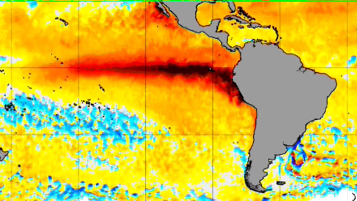
RALEIGH, United States — A very strong El Niño is becoming increasingly likely for the Northern Hemisphere fall and winter of 2026-27, with forecasts indicating that ocean temperatures in the equatorial Pacific could reach unusually high levels. The developing pattern could influence precipitation and storm tracks across the southern United States, although it does not by itself determine the exact weather any particular location will experience.
The U.S. Climate Prediction Center’s August outlook gives a greater than 90% chance of a very strong El Niño during the fall and winter. Other models indicate the event could become even stronger than current forecasts.
Key Highlights
- El Niño is strengthening across the equatorial Pacific, where ocean temperatures are running well above average.
- The chance of a very strong El Niño during fall and winter 2026-27 has risen to above 90% in the latest outlook.
- Very strong El Niño events have been uncommon, with only four such fall and winter seasons identified since 1950 in the supplied analysis.
- El Niño generally reduces Atlantic tropical activity while shifting the storm track toward the southern United States.
- Past very strong El Niño seasons have generally produced wetter conditions, but snowfall has varied considerably.
What Is El Niño?
El Niño occurs when waters in a specific section of the equatorial Pacific become warmer than average. Its counterpart, La Niña, involves cooler-than-average waters in the same broad region.
The climate pattern matters because changes in Pacific Ocean temperatures can influence atmospheric circulation and weather patterns far beyond the Pacific. El Niño can also affect tropical activity and the position of storm tracks across the United States.
Why This El Niño Could Be Unusual
A strong El Niño is defined in the supplied analysis as ocean temperatures between 1.4°C and 1.9°C above average in the relevant region. An anomaly of 2.0°C or more is classified as very strong.
Since 1950, there have been 11 weak, seven moderate, three strong and four very strong El Niño fall and winter seasons. That limited historical sample makes it difficult to draw precise conclusions about what the upcoming season will bring.
The latest outlook suggests the probability of a very strong event has increased from earlier projections. Forecast tracking also indicates that the odds could rise above 90% around September.
What Could El Niño Mean for North Carolina?
For North Carolina, historical El Niño seasons show substantial variation in snowfall. The 30-year average snowfall for the Triangle from 1991 to 2020 was 7.9 inches, but snowfall totals during El Niño winters have differed widely depending on the strength and other atmospheric conditions.
The five strongest El Niño winters illustrate that uncertainty. The winter of 1982-83 was particularly snowy, while the other four strongest events produced much lower snow totals.
That history is why a strong or very strong El Niño should not automatically be interpreted as a prediction of heavy snow. In North Carolina, rain remains more likely than snow during winter.
Rainfall Could Be the Bigger Story
Precipitation records provide a different signal. Most El Niño fall and winter seasons have produced totals close to the 30-year average, while very strong El Niño seasons have tended to bring above-average precipitation.
That could be significant for areas dealing with drought. If the current pattern follows historical behavior, the coming months could shift toward a wetter overall weather pattern, although the available record does not guarantee that outcome.
Texas Could Also See More Storms and Snow
The strengthening El Niño could have important effects farther west. Forecast discussions cited in the supplied material indicate that Texas could experience a wetter fall and winter, with the subtropical jet stream potentially shifting southward and increasing the risk of storms.
One forecast cited in the source projects Texas rainfall could run 25% to 49% above average from September through November. However, heavy downpours do not necessarily resolve long-term drought because intense rainfall can produce flooding without providing sustained moisture for depleted water supplies.
Winter precipitation could also fall as sleet or snow when colder conditions combine with the increased moisture. National Weather Service information cited in the source indicates that West Central Texas has historically experienced increased snowfall during El Niño winters.
Why El Niño Alone Cannot Predict the Entire Winter
Meteorologists caution against treating the El Niño signal as a complete seasonal forecast. Other factors can influence winter conditions, including preceding tropical activity, solar activity and Siberian snow cover.
That means the developing El Niño provides an important climate signal but cannot determine individual storms or guarantee a particular snowfall total. The historical record instead offers probabilities and broad tendencies.
For North Carolina, the strongest early signal is the potential for a wetter season, while snowfall remains much harder to predict. As the fall approaches and additional atmospheric data becomes available, forecasts should become more specific.
Weather disclaimer: Seasonal climate patterns describe broad probabilities and trends, not guaranteed local weather conditions or individual storm forecasts.

Praveen Yadav is the Founder and Editor at The Nation Bulletin. With over 3 years of experience in digital journalism and news reporting, he covers national affairs, governance, and breaking current events with a commitment to factual accuracy and verified reporting.